Isis 3 Application Documentation
maptrim | Standard View | TOC | Home |
Trim edges of a map projected image
Description
Categories
Groups
Examples
History
Description
Note: This application will not handle non-projected images (i.e. images that are not Level2). To trim a Level1 image, please refer to camtrim.
Categories
Related Applications in Previous Versions of Isis
This application replaces the following application existing in previous versions of Isis, which has been deprecated from the current version of Isis:- trimsinu
Parameter Groups
Files
| Name | Description |
|---|---|
| FROM | Input cube to trim |
| TO | Output cube |
Trim options
| Name | Description |
|---|---|
| MODE | Maptrim options |
Trim Parameters
| Name | Description |
|---|---|
| MINLAT | Starting latitude |
| MAXLAT | Ending latitude |
| MINLON | Starting longitude |
| MAXLON | Ending longitude |
Files: FROM
Description
Use this parameter to select the filename. All bands within the file will be trimmed.
| Type | cube |
|---|---|
| File Mode | input |
| Filter | *.cub |
Files: TO
Description
This file will contain the results of the trimmed cube.
| Type | cube |
|---|---|
| File Mode | output |
| Filter | *.cub |
Trim options: MODE
Description
This allows the user to decide which trimming options to use. Normally, all pixels outside the lat/lon ranges are set to NULL. There is now a choice to crop out a part of a map with or without nulled pixels outside the lat/lon range.
| Type | string | ||||||||||||
|---|---|---|---|---|---|---|---|---|---|---|---|---|---|
| Default | TRIM | ||||||||||||
| Option List: |
|
Trim Parameters: MINLAT
Description
Starting latitude of range to exclude from trim. Any pixels whose latitude is less than this value will be set to NULL.
| Type | double |
|---|---|
| Internal Default | Minimum latitude in labels |
| Minimum | -90 (inclusive) |
| Maximum | 90 (inclusive) |
| Less Than |
|
Trim Parameters: MAXLAT
Description
Ending latitude of range to exclude from trim. Any pixel whose latitude is greater than this value will be set to NULL.
| Type | double |
|---|---|
| Internal Default | Maximum latitude in labels |
| Minimum | -90 (inclusive) |
| Maximum | 90 (inclusive) |
| Greater Than |
|
Trim Parameters: MINLON
Description
Starting longitude of range to exclude from trim. Any pixel whose longitude is less than this value will be set to NULL.
| Type | double |
|---|---|
| Internal Default | Minimum longitude in labels |
| Minimum | -360 (inclusive) |
| Maximum | 360 (inclusive) |
| Less Than |
|
Trim Parameters: MAXLON
Description
Ending longitude of range to exclude from trim. Any pixels whose longitude is greater than this value will be set to NULL.
| Type | double |
|---|---|
| Internal Default | Maximum longitude in labels |
| Minimum | -360 (inclusive) |
| Maximum | 360 (inclusive) |
| Greater Than |
|
Examples
Example 1
Trimming a Projected Image
Description
Command Line
Input Image
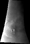
input.cub
|
Input cube
Parameter Name:
FROM This is the input cube to trim. |
Output Image
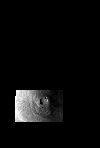
trimmed.cub
|
Trimmed cube
Parameter Name:
TO This is the trimmed cube. Notice that all pixels that fell outside the user-specified range were set to NULL. |
History
| Tracie Sucharski | 2003-02-28 | Original version |
| Tracie Sucharski | 2003-04-03 | Changed brief description, added error check for no values entered for slat,elat,slon,elon. |
| Stuart Sides | 2003-05-16 | Modified schema location from astogeology... to isis.astrogeology..." |
| Stuart Sides | 2003-07-29 | Modified filename parameters to be cube parameters where necessary |
| Brendan George | 2005-11-21 | Added application test |
| Sean Crosby | 2007-03-16 | Added cropping and crop+trim ability; modified apptest |
| Christopher Austin | 2009-01-27 | Fixed parameter names |
| Travis Addair | 2009-08-10 | Mapping group parameters are now placed into the print file. |
| Mackenzie Boyd | 2009-08-12 | Modified call to crop to handle from and to parameters with spaces in directories. |
| Jai Rideout | 2011-01-11 | Updated documentation and testing with Ella Lee in preparation for the 3.4.0 release. Fixed various inconsistencies in the documentation and rewrote some parts to make it clearer. Added an example. Added two new tests to test getting the lat/lon range from the cube labels and the processing of level 1 images. |