

The webmap package in R leverages the JavaScript Leaflet library to create dynamic web maps. It seamlessly integrates with base layers provided by The National Map (TNM), offering essential geospatial information about the landscapes of the United States and its territories.
Users should be aware that detailed base layers for areas outside the United States may not be available at higher spatial scales. While The National Map services are continuously monitored for reliability, availability outside of standard government working hours cannot be assured.
Designed to complement the Leaflet for R package, the webmap package enhances mapping capabilities by providing a range of utility functions that allow users to enrich their web maps with additional features, resulting in engaging and effective visualizations. This makes the process of creating impactful web maps both straightforward and accessible for users of varying skill levels.
To install the current release of the package from CRAN you can use the following command in R:
install.packages("webmap")To install the package along with its dependencies, which are required to run examples in the package help documentation, run:
install.packages("webmap", dependencies = TRUE)To install the development version of the package, you can either clone the repository and build it from source, or run the following commands. Make sure the remotes package for R is installed.
remotes::install_gitlab(
  repo = "inl/webmap@develop",
  host = "code.usgs.gov",
  dependencies = TRUE
)
After installing the package, you can use it in various contexts, including the R console, R Markdown documents, and Shiny applications.
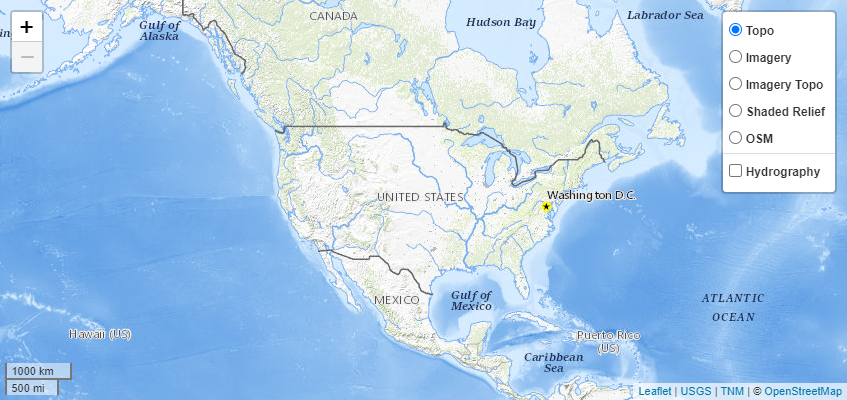
To create the default web map and display it (the screenshot below showns the default web map), you can run the following commands:
library("webmap")
make_map()
The screenshot below shows the default web map that is created by the above commands.
Additional examples are provided in the package help pages. To access these documents, run:
help(package = "webmap")Jason C. Fisher (jfisher@usgs.gov)
To cite webmap in publications, please use:
Fisher, J.C., 2023, webmap—Interactive web maps using The National Map (TNM) services: U.S. Geological Survey software release, R package, Reston, Va., https://doi.org/10.5066/P9CPB1WD.
We value your contributions and suggestions on how to make these materials more useful to the community. Please feel free to share your thoughts by commenting on the issue tracker or opening a merge request to contribute.
All contributions to- and interactions surrounding- this project will abide by the USGS Code of Scientific Conduct.
This software is preliminary or provisional and is subject to revision. It is being provided to meet the need for timely best science. The software has not received final approval by the U.S. Geological Survey (USGS). No warranty, expressed or implied, is made by the USGS or the U.S. Government as to the functionality of the software and related material nor shall the fact of release constitute any such warranty. The software is provided on the condition that neither the USGS nor the U.S. Government shall be held liable for any damages resulting from the authorized or unauthorized use of the software.
Any use of trade, product, or firm names is for descriptive purposes only and does not imply endorsement by the U.S. Government.
Copyright (c) 2023, webmap authors
Permission is hereby granted, free of charge, to any person obtaining a copy of this software and associated documentation files (the “Software”), to deal in the Software without restriction, including without limitation the rights to use, copy, modify, merge, publish, distribute, sublicense, and/or sell copies of the Software, and to permit persons to whom the Software is furnished to do so, subject to the following conditions:
The above copyright notice and this permission notice shall be included in all copies or substantial portions of the Software.
THE SOFTWARE IS PROVIDED “AS IS”, WITHOUT WARRANTY OF ANY KIND, EXPRESS OR IMPLIED, INCLUDING BUT NOT LIMITED TO THE WARRANTIES OF MERCHANTABILITY, FITNESS FOR A PARTICULAR PURPOSE AND NONINFRINGEMENT. IN NO EVENT SHALL THE AUTHORS OR COPYRIGHT HOLDERS BE LIABLE FOR ANY CLAIM, DAMAGES OR OTHER LIABILITY, WHETHER IN AN ACTION OF CONTRACT, TORT OR OTHERWISE, ARISING FROM, OUT OF OR IN CONNECTION WITH THE SOFTWARE OR THE USE OR OTHER DEALINGS IN THE SOFTWARE.
The Idaho National Laboratory Project Office of the USGS supports the development and maintenance of webmap. Resources are available primarily for maintenance and responding to user questions. Priorities on the development of new features are determined by the development team.
Additional metadata about this publication, not found in other parts of the page is in this table.
| Publication type | Formal R language package |
|---|---|
| DOI | 10.5066/P9CPB1WD |
| Year published | 2023 |
| Version | 1.0.0 |
| IPDS | IP-155090 |