
| The Geometry of the Master Plan of Roman Florence and its Surroundings |
|---|
Department of Architecture, Kansas State University
Manhattan, Kansas, USA
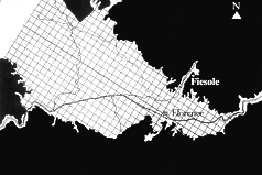
Florence, the Roman Florentia, was founded as a new town to settle military veterans. Like many cities founded by the Romans, it was oriented to the cardinal points. The major streets, a north-south cardo and east-west decumanus, met in the center of the rectangular walled town. A gate was located at each of the four intersections of major street and city wall. A grid of secondary streets divided the city into blocks. Even today, looking at an aerial view or a plan of the city, this orderly central portion of Florence is evident.
 It was standard Roman
practice, when founding a new colony, to survey the countryside
and assign plots of land to the settlers. The crossing of two
major lines, the cardo maximus and decumanus maximus, was established
for the region, as with the layout of a city. The land was then
subdivided into a grid, using lines parallel to the regional
cardo and decumanus, generally into square plots 20 actus on
a side. An actus was 120 Roman feet. Every fifth division was
particularly important, and surveyed more precisely to keep the
system accurate. Each century, as these 20 actus squares were
known, was futher subdivided into farm plots. This process of
organizing the countryside is commonly known as centuriation.
Evidence of such grids upon the countryside can still be seen,
particularly in aerial photography, throughout what had been
the Roman Empire.
It was standard Roman
practice, when founding a new colony, to survey the countryside
and assign plots of land to the settlers. The crossing of two
major lines, the cardo maximus and decumanus maximus, was established
for the region, as with the layout of a city. The land was then
subdivided into a grid, using lines parallel to the regional
cardo and decumanus, generally into square plots 20 actus on
a side. An actus was 120 Roman feet. Every fifth division was
particularly important, and surveyed more precisely to keep the
system accurate. Each century, as these 20 actus squares were
known, was futher subdivided into farm plots. This process of
organizing the countryside is commonly known as centuriation.
Evidence of such grids upon the countryside can still be seen,
particularly in aerial photography, throughout what had been
the Roman Empire.
The steps traced in this paper indicate a logical way in which the colony of Florence, both city and countryside, could have been laid out, consistent with what is known of Roman practices and with the observable traces of the Roman settlement. Relatively simple geometrical operations integrate the city with its landscape, and with the cosmos as well. The landscape of the region, linked with the cosmos through the path of the sun, provided the initial positioning of the city. A geometry based on the 3:5 triangle establishes the precise rotational relationship between the two levels of scale, the region and the city. A conceptual square mediating between the two orientations, and its sacred cut, establishes the limits of the city to the east, north and south. The further use of the 3:5 triangle locates the center of the city, and its cardo, as well as its western edge. What at first glance may seem to be a pragmatic adaptation to the site conditions is shown to be a rigorous geometric relationship, predicated on using a meaningful set of whole numbers, in an affirmation of the genius loci of Florentia.
ILLUSTRATION:
ABOUT
THE AUTHOR
Carol
Martin Watts is
an architectural historian and faculty member in the Department
of Architecture at Kansas State University, Manhattan, Kansas.
She received her Ph.D. from the University of Texas at Austin,
writing her dissertation on "A Pattern Language for Houses
at Pompeii, Herculaneum and Ostia." She has published several
articles, together with Donald
J. Watts, on geometry in Roman architecture, painting and
mosaics, including "A Roman Apartment Complex" in Scientific
American. Her current research interests include vernacular Italian
architecture and the impact of Roman development on subsequent
layers in urban environments. She is a member of the editorial
board of the NNJ. She presented "The
Square and the Roman House: Architecture and Decoration at Pompeii
and Herculaneum" at Nexus '96, now available in Nexus:
Architecture and Mathematics.
|
Carol Martin Watts, "The Geometry of the Master Plan of Roman Florence and its Surroundings", pp. 169-181 in Nexus III: Architecture and Mathematics, ed. Kim Williams, Pisa: Pacini Editore, 2000. http://www.nexusjournal.com/conferences/N2000-Watts.html |
|
|
|
|